P634 Occultation June 10, 2009
(last updated 2009 03 17)
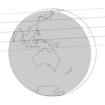
The shaded area represents where the sun is more than 12 degrees below the horizon. Across the globe pictured above, the three lines correspond to the northern limit, centerline, and southern limit of Pluto's shadow. The northern and southern limits correspond to a radius of 1208 km (the 50% normalized stellar-flux level) for Pluto. The dashed lines represent the upper and lower limits for the track given the prediction error listed on this page.
|
| Geocentric Mid-time (yyyy month dd hh:mm:ss) |
2009 June 10 15:21:38± 00:00:56 UT |
| Minimum Geocentric Separation |
0.1422± 0.0575 arcsec |
| Position Angle (Pluto relative to the star; measured north through east) |
–3.25 degrees |
| Geocentric Velocity |
23.09 km/sec |
| Prediction Version |
P634-AST-1.0 |
Reference star position:
(USNO-B1.0, at epoch of event) |
RA (h:m:s; J2000) |
Dec (d:m:s; J2000) |
R Mag1 |
| P634 Catalog2 |
18 09 03.3007 |
–17 38 33.746 |
15.5 |
| P634 Measured |
18 09 03.2921 |
–17 38 33.600 |
16.73 |
|
|
|
Offsets from Reference Position/Ephemeris4 |
| Body |
RA (arcsec) |
Dec (arcsec) |
Notes |
P634 |
–0.1278± 0.0580 |
+0.146± 0.055 |
From 5 Strips |
| Pluto5 |
–0.0478± 0.0112 |
+0.143± 0.015 |
See note 6 |
4All "offsets" are defined in the ("corrected" – "reference") or ("observed" – "calculated") sense. The offsets should be added to reference positions to get the measured positions, which we use to calculate the prediction.
5The reference position for Pluto is that given by JPL Horizon's ephemeris (Pluto source file: PLU017; Earth center source file: DE405).
6315 strip scans and 89 USNO-61inch Telescope frames were used to develop a model to fit the residuals obtained from our measured positions compared to that of the object's JPL ephemeris.. The model includes the first-order effects of errors in the orbital elements of Pluto: (i) constant offsets in RA and Dec, (ii) linear (in time) offsets in RA and Dec, (iii) sinusoidal terms with the Earth's orbital period, and (iv) sinusoidal terms with the Pluto-Charon mutual orbit.
|
Discussion
On June 10th, 2009, Pluto will occult P634 (=USNO-B 0723-0776423; as originally published in McDonald & Elliot 2000a, 2000b; Table). The above map and the following prediction results are from measured Pluto and P634 offsets. The Pluto offsets were obtained from our Pluto Ephemeris Correction Model (E.C.M). Our Pluto E.C.M. contains the analysis of 315 strip scans obtained at the Lowell Observatory Astrograph by Rosemary Pike, Amanda Bosh, and Allison Moberger during 2005-2008 (the strip scans from earlier years did not contain Pluto-Charon images) and 89 frames taken on 2005 and 2007 by Steve Levine with the 1.55-m Kaj Strand Astrometric Reflector. The star offsets were obtained from 5 of the strips taken of the Pluto 2009 star field.
Prediction Notes
Site Information
Site |
East Longitude |
Latitude |
Altitude7
(km) |
Distance8
(km) |
Velocity
(km/s) |
ARIES (Naini Tal) |
+79 27 24 |
29 21 42 |
1.927 |
678 N. |
23.30 |
Bosscha Obs. |
+107 37 00 |
–06 49 30 |
1.300 |
2273 S. |
23.49 |
Girawali Observatory |
+73 40 00 |
19 05 00 |
1.005 |
370 S. |
23.28 |
Indian Astro. Obs. |
+78 57 54 |
32 46 48 |
4.467 |
940 N. |
23.29 |
Purple Mountain Obs. |
+118 49 18 |
32 04 00 |
0.267 |
1478 N. |
23.46 |
Vainu Bappu Obs. |
+78 49 36 |
12 34 36 |
0.725 |
855 S. |
23.32 |
Geocentric |
---------- |
--------- |
center of Earth |
3339 S. |
23.09 |
7Altitude of each observatory is measured in kilometers above sea level.
8"Distance" refers to the closest approach distance of the "Site" to the center of Pluto's shadow in the shadow plane. The errors on all closest approach distances are ±1278 km (one standard deviation). "S." means the site is South of the center of Pluto's shadow. "N." means the site is North of the center of Pluto's shadow.
P634 Occultation Predictions for Individual Sites
Site |
Pluto Immersion (UT)10 |
Mid-Time (UT)10 |
Pluto Emersion (UT)10 |
ARIES (Naini Tal) |
15:24:08 |
15:25:01 (14°) |
15:25:54 |
Bosscha Obs. |
----------- |
15:24:10 (54°) |
----------- |
Purple Mountain Obs. |
----------- |
15:22:59 (35°) |
----------- |
Girawali Observatory |
15:24:34 |
15:25:32 (14°) |
15:26:30 |
Indian Astro. Obs. |
15:24:09 |
15:24:54 (12°) |
15:25:38 |
Vainu Bappu Obs. |
15:24:44 |
15:25:32 (21°) |
15:26:19 |
Geocentric |
----------- |
15:21:37 |
----------- |
10The errors on all mid-times are ±0:56 (56 seconds; one standard deviation). In parenthesis is the elevation of the body above the celestial horizon in degrees.
11At the closest approch time for that location.
Last updated by Carlos A Zuluaga (email)
2009-03-17 12:30
Please direct all inquiries to Planetary Astronomy Lab (planetary-astronomy@mit.edu)
Accessibility