55636.20091009 Occultation October 09, 2009
(last updated 2009 09 08)
|
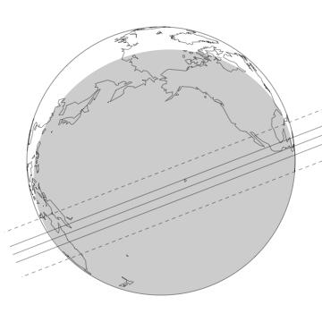
Across the globe pictured above, the three lines correspond to the northern limit, centerline, and southern limit of 55636's shadow. The northern and southern limits correspond to a radius of 405 km (from kboOccCandByAndRad.1.5.csv). The error in the prediction (3 Standard Deviations from the limb of the KBO) is depicted by the upper and lower dashed lines. The shaded area represents where the sun is more than 12 degrees below the horizon.
|
| Geocentric Mid-time (yyyy month dd hh:mm:ss) |
2009 October 09 10:30:23± 00:00:351 UT
|
| Minimum Geocentric Separation |
0.0546± 0.02491 arcsec |
| Position Angle (55636 relative to the star; measured north through east) |
158.90 degrees |
| Geocentric Velocity |
25.29 km/sec |
| Prediction Version |
555636.20091009-AST-11.0 |
1Three Standard Deviations.
Reference star position:
(UCAC2, at epoch of event) |
RA (h:m:s; J2000) |
Dec (d:m:s; J2000) |
UCAC2 mag2 |
| 55636.20091009 Catalog2 |
00 37 13.6103 |
28 22 22.981 |
13.1 |
| 55636.20091009 Measured |
00 37 13.6191 |
28 22 23.021 |
|
2The UCAC bandpass (579-642nm) is between V and R.
|
|
Offsets from Reference Position/Ephemeris3 |
| Body |
RA (arcsec) |
Dec (arcsec) |
Notes |
55636.20091009 |
+0.1317± 0.0035 |
+0.039± 0.003 |
From 11 USNO40 frames and 18 USNO61; See Note 5 |
| 556364 |
+0.2756± 0.0098 |
–0.066± 0.007 |
See Note 6 |
3All "offsets" are defined in the ("corrected" – "reference") or ("observed" – "calculated") sense. The offsets should be added to reference positions to get the measured positions, which we use to calculate the prediction.
4The reference position for 55636 is that given by JPL Horizon's ephemeris (55636 source file: JPL#7; Earth center source file: DE405).
5A weighted average of the data from the two telescopes was used to calculate the RA/DEC offsets. The errors given are 1 standard deviation.
6SMARTS, USNO40, adn USNO61 frames were used to develop a model to fit the residuals obtained from our measured positions compared to that of the object's JPL ephemeris. The model includes the first-order effects of errors in the orbital elements of 55636: (i) constant offsets in RA and Dec, (ii) linear (in time) offsets in RA and Dec, and (iii) sinusoidal terms with the Earth's orbital period.
The errors listed for the KBO and the Occultation Star are 1 standard deviation.
|
Discussion
On 2009 October 9th, 55636 (2002 TX300) will occult will occult 2UCAC number 41650964. The above map and the following prediction results are from the analysis of 52 frames obtained using the United States Naval Observatory 61-inch and 40-inch, and the SMARTS 0.9m telescope. The 52 frames, which range from August 2007 to August 2009, were used to develop a model to fit the residuals from our measured positions compared to that of the object's JPL ephemeris. The model includes the first-order effects of errors in the orbital elements of 55636: (i) constant offsets in RA and Dec, (ii) linear (in time) offsets in RA and Dec, and (iii) sinusoidal terms with the Earth's orbital period.
For the occultation star, 29 frames obatined using the United States Naval Observatory 61-inch and 40-inch were used to calculate the RA and Dec offsets from the UCAC2 values.
Precise Astrometry of KBOs is difficult to carry out due to their faint magnitudes and small angular radii. In the case of 55636, which has a visual magnitude of 19.6 and angular radius of 0.013 arcseconds (from an assumed radius of 405 km), accurately predicting an occultation can be difficult.
Site Information
The sites in the table below are listed in order of their distance from the predicted centerline, starting with the most northern site.
Site |
East Longitude |
Latitude |
Altitude6
(km) |
Distance7
(km) |
Velocity
(km/s) |
Behlen Observatory (Nebraska U.) |
–96 26 48 |
41 10 18 |
0.362 |
2673 N. |
25.47 |
Fickle Hill Observatory |
–123 59 09 |
40 48 08 |
0.61 |
2266 N. |
25.49 |
Puckett Observatory |
–84 55 00 |
33 45 00 |
0.30 |
2243 N. |
25.42 |
Lick Obs. |
–121 38 12 |
37 20 36 |
1.29 |
1892 N. |
25.58 |
Fremont Peak |
–121 29 55 |
36 45 36 |
0.84 |
1828 N. |
25.59 |
USNO |
–111 44 24 |
35 11 00 |
2.31 |
1741 N. |
25.55 |
M.R.O. |
–107 11 05 |
33 58 36 |
2.22 |
1679 N. |
25.54 |
Pomona College |
–117 42 35 |
34 05 51 |
0.35 |
1558 N. |
25.58 |
Puerto Rico (Arecibo) |
–66 45 12 |
18 20 36 |
0.50 |
1506 N. |
25.31 |
Mt. Graham (VTT) |
–109 53 21 |
32 42 04 |
3.19 |
1495 N. |
25.56 |
Palomar |
–116 51 54 |
33 21 24 |
1.71 |
1483 N. |
25.58 |
Arizona Sky Village (David Churchill) |
–109 07 33 |
31 56 49 |
1.4 |
1425 N. |
25.55 |
Arizona Sky Village (Jack Newton) |
–109 07 08 |
31 55 30 |
1.4 |
1423 N. |
25.55 |
McDonald Observatory (Mt. Locke) |
–104 01 21 |
30 40 17 |
2.08 |
1380 N. |
25.53 |
Guillermo Haro Obs. |
–110 23 05 |
31 03 10 |
2.480 |
1308 N. |
25.58 |
San Pedro Martir, Mexico |
–115 27 49 |
31 02 39 |
2.83 |
1242 N. |
25.58 |
Brownsville, Texas |
–97 29 22 |
25 56 47 |
0.121 |
1032 N. |
25.51 |
Leeward Community College |
–157 59 04 |
21 23 28 |
0.02 |
600 N. |
25.70 |
Windward Community College |
–157 48 54 |
21 24 36 |
0.06 |
597 N. |
25.70 |
Haleakala |
–156 15 24 |
20 42 24 |
3.05 |
478 N. |
25.70 |
IRTF |
–155 28 29 |
19 49 46 |
4.18 |
364 N. |
25.70 |
Mauna Kea Mid-Level |
–155 27 15 |
19 45 36 |
2.8 |
356 N. |
25.70 |
Tonantzintla Observatory |
–98 18 50 |
19 01 58 |
2.2 |
282 N. |
25.52 |
Acapulco |
–99 53 16 |
16 51 33 |
0.0 |
13 N. |
25.54 |
Obs. Ast. de la UNAN - Managua (Nicaragua) |
–86 16 14 |
12 06 25 |
0.25 |
11 N. |
25.69 |
Cairns, Australia |
145 46 28 |
–16 55 25 |
0.08 |
143 S. |
25.50 |
Black Springs |
138 53 18 |
–33 53 58 |
0.47 |
1138 S. |
25.43 |
Toowoomba |
151 57 00 |
–27 34 12 |
0.69 |
1362 S. |
25.51 |
Siding Spring |
149 03 44 |
–31 16 17 |
1.21 |
1481 S. |
25.49 |
Grove Creek Obs. (Sydney) |
149 21 59 |
–33 49 46 |
0.90 |
1682 S. |
25.48 |
Mount Stromlo |
149 03 44 |
–35 18 57 |
0.81 |
1768 S. |
25.48 |
Hobart |
147 26 24 |
–42 48 18 |
0.04 |
2185 S. |
25.45 |
Mt. John |
170 27 50 |
–43 59 22 |
1.04 |
3252 S. |
25.54 |
Geocenter |
---------- |
--------- |
center of Earth |
1618 S. |
25.29 |
6Altitude of each observatory is measured in kilometers above sea level.
7"Distance" refers to the closest approach distance of the "Site" to the center of 55636's shadow in the shadow plane. The errors on all closest approach distances are ±734 km (three standard deviations). "S." means the site is South of the center of 55636's shadow. "N." means the site is North of the center of 55636's shadow.
55636.20091009 Occultation Predictions for Individual Sites
Site |
55636 Immersion (UT)9 |
UT Mid-Time (Altitude / Solar Altitude)9 |
55636 Emersion (UT)9 |
Acapulco |
10:26:36 |
10:26:52 (27°) |
10:27:08 |
Arizona Sky Village (Jack Newton) |
----------- |
10:27:15 (41°) |
----------- |
Arizona Sky Village (David Churchill) |
----------- |
10:27:15 (41°) |
----------- |
Behlen Observatory (Nebraska U.) |
----------- |
10:26:56 (33°) |
----------- |
Black Springs |
----------- |
10:34:06 (11°) |
----------- |
Brownsville, Texas |
----------- |
10:26:47 (30°) |
----------- |
Cairns, Australia |
10:33:44 |
10:33:59 (27°) |
10:34:14 |
Fickle Hill Observatory |
----------- |
10:27:57 (52°) |
----------- |
Fremont Peak |
----------- |
10:27:49 (51°) |
----------- |
Guillermo Haro Obs. |
----------- |
10:27:17 (42°) |
----------- |
Grove Creek Obs. (Sydney) |
----------- |
10:33:47 (17°) |
----------- |
Haleakala |
----------- |
10:29:56 (78°) |
----------- |
Hobart |
----------- |
10:33:42 (9°) |
----------- |
Leeward Community College |
----------- |
10:30:02 (78°) |
----------- |
Lick Obs. |
----------- |
10:27:49 (51°) |
----------- |
M.R.O. |
----------- |
10:27:11 (40°) |
----------- |
IRTF |
10:29:47 |
10:29:54 (76°) |
10:30:01 |
Mauna Kea Mid-Level |
10:29:47 |
10:29:54 (76°) |
10:30:02 |
McDonald Observatory (Mt. Locke) |
----------- |
10:27:02 (37°) |
----------- |
Mt. Graham (VTT) |
----------- |
10:27:17 (41°) |
----------- |
Mt. John |
----------- |
10:32:51 (17°) |
----------- |
Mt. Stromlo |
----------- |
10:33:47 (15°) |
----------- |
Obs. Ast. de la UNAN - Managua (Nicaragua) |
10:26:13 |
10:26:29 (15° / -16°) |
10:26:45 |
Palomar |
----------- |
10:27:35 (46°) |
----------- |
Pomona College |
----------- |
10:27:38 (48°) |
----------- |
Puckett Observatory |
----------- |
10:26:31 (21° / -15°) |
----------- |
Puerto Rico (Arecibo) |
----------- |
10:26:11 (21° / 2°) |
----------- |
San Pedro Martir, Mexico |
----------- |
10:27:31 (46°) |
----------- |
Siding Spring |
----------- |
10:33:49 (18°) |
----------- |
Tonantzintla Observatory |
10:26:37 |
10:26:48 (28°) |
10:26:59 |
Toowoomba |
----------- |
10:33:45 (23°) |
----------- |
USNO |
----------- |
10:27:22 (42°) |
----------- |
Windward Community College |
----------- |
10:30:01 (78°) |
----------- |
Geocentric |
----------- |
10:30:26 |
----------- |
9The errors on all times are ±0:35 (35 seconds; Three standard deviations). In parenthesis is the elevation of the body above the celestial horizon in degrees. The Solar altitude is given for locations where it is relevant (past astronomical twilight). No entry in the Immersion and Emersion columns indicates that the occultation is not predicted to be visible at that site. But because the errors are large, some of these sites may see an occultation event that would be centered on the time in the "UT Mid-Time" column.
Last updated by Carlos A Zuluaga (czuluaga@mit.edu)
2009-09-08 10:00
Please direct all inquiries to Planetary Astronomy Lab (planetary-astronomy@mit.edu)
Accessibility