Chiron.20111129 Occultation November 29, 2011
(last updated 2011 08 09)
OBSERVER NOTES
|
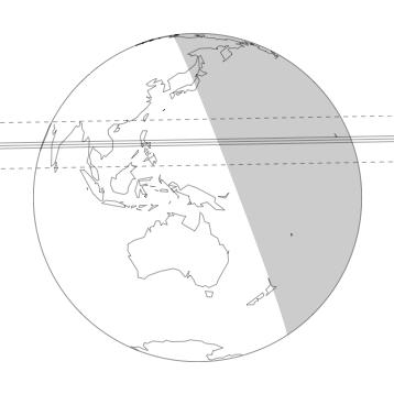
Across the globe pictured above, the three solid lines correspond to the northern limit, centerline, and southern limit of Chiron's shadow. The northern and southern limits correspond to a radius of 108 km. The upper and lower dashed lines indicate 3 sigma error. The shaded area represents where the sun is more than 12 degrees below the horizon.
The scientific goals of this event are (i) to accurately determine the diameter of Chiron, (ii) to probe for a tenuous atmosphere of Chiron, and (iii) to detect possible nearby satellites of Chiron.
Observations are worthwhile and encouraged from any location at which the star is visible, due to the possibilities of the occultation star being a multiple star system or the KBO having a satellite. Either of these could move the event by more than the random uncertainties shown.
|
|
Table 1: Prediction Details |
| Geocentric Mid-time (yyyy month dd hh:mm:ss) |
2011 November 29 08:06:31± 00:00:191 UT |
| Minimum Geocentric Separation |
0.156± 0.0631 arcsec |
| Position Angle (Chiron relative to the star; measured north through east) |
–1.02 degrees |
| Geocentric Velocity |
9.87 km/sec |
| Occultation Star UCAC2 magnitude |
14.8 |
| KBO Visual Magnitude |
18.3 |
| KBO Angular Radius |
0.008 arcseconds (approximate)
|
1One standard deviation of random error.
Table 2: Reference Star Position |
Reference star position:
(UCAC2, at epoch of event) |
RA (h:m:s; J2000) |
Dec (d:m:s; J2000) |
Notes |
| Chiron.20111129 Catalog |
22 02 44.3056 ± 0.077 |
– 05 55 12.27 ± 0.090 |
|
| Chiron.20111129 Measured3 |
22 02 44.3042 ± 0.077 |
– 05 55 12.23 ± 0.090 |
from 4 CTIO SMARTS 0.9-m frames |
|
Table 3: Projected KBO Offsets4 from Reference Ephemeris at the Time of the Event |
| Body |
RA (arcsec) |
Dec (arcsec) |
|
| Chiron |
–0.0384± 0.0129 |
–0.294± 0.019 |
See Notes 5 and 6 |
3Measured position corresponds to RA offset of -0.022 and Dec. offset of +0.044.
4All "offsets" are defined in the ("corrected" – "reference") or ("observed" – "calculated") sense. The offsets should be added to reference positions to get the measured positions, which we use to calculate the prediction.
4Data analyzed using UCAC2 reference network. A weighted average of the data from the two telescopes was used to calculate the RA and DEC. The errors given are 1 standard deviation.
5The reference position for Chiron is that given by JPL Horizon's ephemeris (Chiron source file: JPL#79; Earth center source file: DE405).
6Data from the USNO 61-inch, SMARTS 0.9m, and Lowell 42-inch telescopes over the span of 3 years were reduced with respect to stars in the UCAC2 catalog. A model was developed to fit the residuals obtained from our measured positions compared to that of the object's JPL ephemeris. All residuals obtained from the different telescopes were consistent with the model. The model includes the first-order effects of errors in the orbital elements of Varuna: (i) constant offsets in RA and Dec, (ii) linear (in time) offsets in RA and Dec, and (iii) sinusoidal terms with the Earth's orbital period. The model was propagated to obtain the predicted position and error of the KBO at the time of the occultation. The errors listed for the KBO are 1 standard deviation.
|
Table 4: Site Information
The sites in the table below are listed in order of their distance from the predicted centerline, starting with the most northern site.
Site |
Longitude |
Latitude |
Site Altitude6
(km) |
Distance7
(km) |
Velocity
(km/s) |
IRTF |
-155 28 29 |
19 49 46 |
4.182 |
147 N. |
9.87 |
Geocenter |
---------- |
--------- |
center of Earth |
2146 S. |
10.09 |
6Altitude of each observatory is measured in kilometers above sea level.
7"Distance" refers to the closest approach distance of the "Site" to the center of Varuna's shadow in the shadow plane. The errors on all closest approach distances are ±786 km (three standard deviations). "S." means the site is south of the center of Varuna's shadow. "N." means the site is north of the center of Varuna's shadow.
Table 5: Chiron.20111129 Occultation Predictions for Individual Sites
Site |
Varuna Immersion (UT)9 |
UT Mid-Time |
KBO Altitude |
Solar Altitude9 |
Varuna Emersion (UT)9 |
IRTF |
----------- |
08:15:36 |
21° |
----------- |
----------- |
Geocenter |
----------- |
08:06:31 |
------ |
----------- |
----------- |
9The errors on all times are ±0:19 (19 seconds; one standard deviation). The solar altitude is given for locations where it is relevant (solar altitude greater than -18°). No entry in the immersion and emersion columns indicates that the occultation is not predicted to be visible at that site. But due to unknown effects (stellar or KBO duplicity), some of these sites may see an occultation event that would be centered on the time in the "UT Mid-Time" column.
Last updated by Carlos Zuluaga (czuluaga@mit.edu)
2011-09-01 10:10
Please direct all inquiries to pal (pal@mit.edu)
Accessibility